

Drone Technology in Real Estate: Aerial Imaging and Inspections

In the past few years, innovative advancements have taken place in drone technology, making it possible to have numerous applications in most industries. One of the industries that has been greatly affected by this innovation is real estate.
Drones have changed the landscape of property marketing, property surveying, and property research, giving real estate specialists an advanced arsenal for better services, greater productivity, and improved customer satisfaction. The objective of this article is to analyze the impact of drone technology on aerial imaging and inspection in real estate, its various benefits and current uses, and its expected future growth.
The Rise of Drone Technology in Real Estate
Initially intended for military applications, drones or unmanned aerial vehicles (UAV) were sophisticated devices that were relatively unexplored by civilian imagination until recently. In the last ten years, however, many civilian applications have emerged, including agriculture, movie making, logistics, and particularly real estate, among others. They are, after all, machine efficiency, particularly in property marketing, where there is a great need for aerial imaging and closeness that cannot be achieved via other means.
Realtor's operations are made easier with the use of drones since the activities such as evaluating the areas where the structures would be built to ensure that the construction is carried out on a clear site take less time, are cheaper, and provide more precise messaging than would be the case with conventional means. Such benefits have lead to the quicker embracement of penetrating in the drones in both residential and commercial property sectors for example, from advertising the new construction to the building survey.
Drones for Real Estate: Buy, Sell, Rent Property with the help of Aerial Mapping
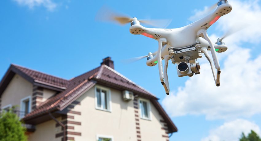
One potential use of drone technology in real estate is Aerial Imaging. It is true that aerial photography and videography have been in use for some time in real estate, but the usage of drones has taken it a notch higher. Apart from drones, chatbots in real estate services are also transforming the way agents interact with clients by providing instant responses and enhancing overall customer experience.
Unfortunately in the past with the aid of high-quality aerial cameras, photographing the roof of the house may have required the use of a chopper or a crane which was costly, slow and nearly impossible for everyday practices. Drones, on the other hand, can provide excellent aerial photographs at a reasonable price with no hassle.
Superb Images and Different Angles
Drones can take high-definition photos and videos in areas and at elevations that previously could not be accessed. This helps prospective buyers appreciate the location of the property, its layout, and its environment. For instance, an aerial view of a single-family house or a commercial structure will not only show the building under focus but also highlight the closeness of the facility to other aspects like parks, schools, and shopping and transport systems. Such visuals provide potential buyers with a wider perspective and so assist them in making sound decisions even before they opt for an actual viewing of the property.
The provision of wide-angle and full 360-degree videos can also increase the likelihood of sale listings. Drones which figure 8 movements can also fly above and around the place, allowing users to appreciate the exact size of the building as well as its surroundings. Real estate professionals can use these images in website listings, during the virtual walkthroughs and in the marketing clips, which is more fruitful than flat images only.
Time and Cost Efficiency
When it comes to aerial imaging, utilizing a drone is considerably more economical than renting out a helicopter or craning the camera in, which can be quite costly. Drones can be set up and ready to operate within minutes and are able to shoot pictures of all angles of the building within a short frame of time. This not only helps in costs but also enhances the overall efficiency of the marketing process, enabling real estate practitioners to create excellent images and market their properties in a very short time.
In addition, these vessels allow taking pictures at different hours and under different lighting conditions which gives real estate agents the opportunity to shoot the properties in a way helping to sell them. Be it the turn of the day sunset or in the middle of the day sunny shot, humanity's invention of the flying gadgets gives the chance of the best angle possible to all houses only one wish is to make a prayer.
Assessment of Property Using Drones Inspection Services
Apart from the advertisement, drones have also found a significant application in property inspection. Conventional methods of inspecting the outsides of huge and hard to reach buildings could be tiring. While inspecting or maintaining tall buildings, professionals or maintenance personnel would often have to use ladders, scaffolding, or cranes to get to higher sections, which was a long and dangerous venture as well. The inspections can be completed quickly and cheaply with the help of a drone.
Roof and Building Inspections
One of the best examples of the simplification of property assessments with drones is roof inspections. A roof inspection is also a risky task, especially for tall or steep buildings. High-resolution cameras attached to drones are able to fly across a roof's surface and take clear photos of the roof, its gutters, chimneys, and other similar features. This is very helpful to assess the roof of the property soon after a storm or while checking the condition of old houses or commercial buildings which involve a lot of repair work.
Drones can thermal imaging in also looking for problems that cannot be seen with the naked eye. For example, they can show areas that have heat loss from the building, meaning that there may be insulation or even leaking issues. This technology is accurate to levels that are impossible to achieve with manual inspection.
Inspections of Buildings and 3D Scanning Techniques
Specialized tools like LiDAR (Light Detection and Ranging) can be attached to drones for 3D mapping and precise measurements of different structures. This feature is most advantageous in scenarios involving huge commercial properties, restoration work, and construction sites, as the accurate dimensions and the existing state of the building are particularly important.
LiDAR or Photogrammetry allows a drone to construct a 3-dimensional image of a site or a structure. These images are helpful in evaluating the existing state of the property, making designs for renovations, or drawing accurate plans for the future constructions. Drones in the construction sector can even help in the tracking of a building project physically. Ensure that the construction work in progress remains within the time frame, and the structure conforms to the design.
Surveillance and Preventive Maintenance
Drone inspections, apart from enabling inspection of surfaces in a building at a time, also enable looking after the buildings over fixed periods of time. Real estate proprietors and managers of properties may, therefore, arrange for regular drone inspection to ensure there are no problems that would later turn out in future to be grave. Early detection of little issues assists property managers in avoiding huge costs that in turn helps in maximizing the lifespan of the property.
For instance, aerial vehicles equipped with cameras may be used for inspecting bridges, towers, wind turbines and any other facility that demands periodic inspection to check for degradation. Drones allow owners to do the monitoring on a regular basis while avoiding the regular expensive and time-consuming interventions of manual surveys.
The Role of Drones in the Commercial Real Estate Industry
These days, drones find great importance in the marketing and management of properties in commercial real estate. This is because large commercial structures such as office blocks, storage units, and malls stand to have improved visibility with the help of aerial imaging and aerial inspections. Take for example capturing aerial shots of large buildings, whether for parking lots, sprawling office parks or massive retail stores. Potential clients, whether buyers or tenants, will have the property's geographical layout including the environment well internalized.
For professionals involved in the commercial property market, drones are useful tools that can employ even in their asset management or portfolio management activities after it has served its marketing function. Drones help in the regular maintenance of multiple properties, reducing expenditure on the upkeep of building structures and increasing their operational efficiency.
Conclusion
In the contemporary world of real estate, drone technology has changed the normal activities of real estate operatives by giving them new ways to market houses, evaluate them and even manage them. Be it aerial photographs or virtual viewing of objects or climbing up the roof for inspection or even preparing 3D modeling , drones have an effectiveness, security and accuracy which was never there before.
As the change continues with the enhancement of drone technology in the real estate sector, it is expected that the change will enhance even more in the near future. Luxurious property marketing, routine maintenance and the building of the drone are going to be part and parcel of a modern day real estate agent.
Ready to grow your business with Jamtech?
Talk to our experts about your next digital project.